A Brief Guide to Mount Wakefield
An off-track adventure with some of the finest views in Aoraki/Mt Cook National Park
Over the years I’ve been fortunate to spend a lot of time in the Aoraki/Mt Cook area. While I’ve always known about Mt Wakefield (2058m) – after all, its long north-south ridgeline and steep scree slopes dominate the view to the north-east of Mt Cook village – I’d never really thought about climbing it. Probably because it doesn’t have an established track, and as such, it’s never rated a mention among the popular walks of the area.
I shouldn’t have waited so long. The Wakefield ridge and summit offers arguably the best 360 degree views of the entire area. Why it hasn’t yet been turned into a developed track is anyone’s guess. (But sshhhh, let’s kept it that way!)
There are many ways up Mt Wakefield but none of them are particularly easy. The shortest way is via one of the many chutes from either the Hooker or Tasman Valleys, however, steep slopes with bluffs and unstable rock are among the hazards. I elected to take a longer but slightly easier-going route, which starts at Hooker Corner on the Tasman Valley Road.
A rough and un-marked track starts at the 700m contour and leads steeply through a brief section of beech forest and then sub-alpine scrub. I’d started walking at around 6am in the pitch black, and even with a headlamp lost the path a couple of times and had to backtrack. At around the 1,100m contour both the scrub and contours begin easing off. A vestige of a path remains, but in any event, the obvious ridgeline is the only way up. At a couple of points the path veers close to bluffy drop-offs but it’s all very manageable. Some great views across to Mt Sefton (3151m) and back down the Tasman Valley are on offer.

First light and my first opportunity to get the camera out

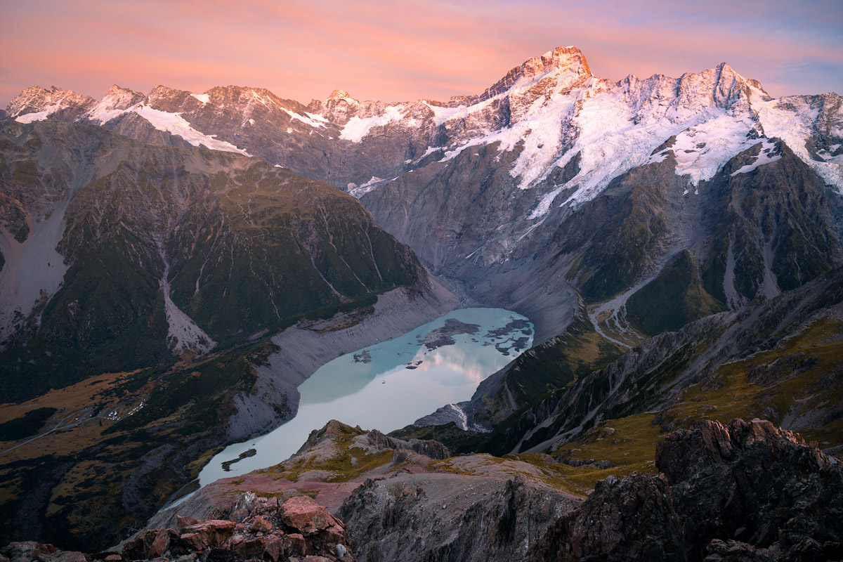
An incredible view back down the Tasman Valley towards Lake Pukaki, taken near pt 1566
At pt 1566 the terrain gets more interesting and some scrambling is required. I imagine this must be the turn-around point for many, as after here any sense of a trail all but disappears. The ridgeline switches to the north-west with several more scrambles on offer, although these can be avoided by losing some elevation and sidling underneath. A short but steep climb through some loose and rocky terrain then brings the route onto the ridge south-east of pt 1827.
Rather than continuing along the challenging ridgeline to pt 1827 it’s much easier to take an elevation penalty and drop into the basin before climbing back up. I found my campsite adjacent to the large crescent-shaped tarn at the northern end of the basin. Total time for me at this point was just under 6 hours, although that included a lunch break and several photography stops. (On the return leg it took me 3 hours to get down from here.)

Mt Sefton (3151m) and Mueller Lake, taken down the ridge from pt 1827

My campsite (approx elevation 1680m); there’s plenty of opportunities to pitch a tent in the basin to the south of pt 2012

A very cold first night led to a solid coat of ice on all the tarns near my campsite

Mt Sefton reflecting in one of the many tarns in the area
After setting up camp and exploring the surrounds for an hour or so, it was time to head to the Mt Wakefield summit. From the basin the route up to pt 2012 is not super obvious, with precipitous bluffs or steep scree seemingly blocking most routes. I ascended the tussocky ridge to the north-east at which point a relatively straight-forward path through the bluffs revealed itself. Although as was becoming a regular occurrence at this point there were still a lot of loose and occasionally steep rock slopes to negotiate. At pt 2012 the appearance of a radio repeater station briefly interrupts the wilderness experience before Mt Wakefield’s summit finally comes into view just several hundred metres away.
For a short period on the last approach the going is flat and relatively easy. It gives an opportunity to scan the summit and plan the route up. Trouble was, the closer I got the less certain about the way forward I became; chossy buttress rock interspersed with guts of steep scree gave no obvious sign of a way through. A line did eventually reveal itself, although for me this last ascent was certainly the trickiest part of the entire trip (more especially when I had to descend in the dark).
Once on the summit ridge the terrain is back to being straight-forward again – reasonably flat and even a couple of places you could pitch a tent. I stayed until after sunset before making the 90-minute walk back to the campsite in the dark. After a quick meal I collapsed into my sleeping bag after a long day.

Hooker Lake, Hooker Glacier, and Aoraki/Mt Cook (3724m), viewed from the summit of Mt Wakefield (2058m)

The three summits of Aoraki / Mt Cook; Low Peak (3593m), Middle Peak (3717m) and High Peak (3724m)

View back along the southern approach of Mt Wakefield to pt 2012, with Lake Pukaki in the distance

The many braids of the Tasman River

The gnarled northern face of Mt Blackburn (2409m)
I spent the next day chilling out (quite literally – it was freezing!) near my campsite and exploring the surrounds. On three occasions I went on a 25-minute walk to a nearby high point, which provided amazing views across to Mt Sefton and back down the Tasman Valley. On the last occasion, I experienced the conditions I’d planned this entire trip around; the onset of a north-west storm which brought incredible sunrise conditions. For close to two hours I witnessed the most beautiful transitions of light and colour I’ve seen in a very long time. To say I was a happy photographer was an understatement!
Later that day, after I’d made it back down, the weather truly kicked in and strong winds and 200mm of rain arrived. The next day, the basin where I’d camped was carpeted in a fresh blanket of snow.
A trip I won’t soon forget.

Sunrise illuminating Mt Sefton (3151m) on my first morning

The last of the day’s sun lights up the braids of the Tasman River

A full moon provides plenty of illumination for long exposure photography; this 174 second shot catches the headlights of cars moving along State Highway 80 towards Mt Cook Village

Sunrise on my last morning; the conditions I’d been dreaming of [click image to purchase print]

Another glorious view down the Tasman Valley; Mt Cook airport can be seen centre-right
Progression of a sunrise #1: 6.38am [click image to purchase print]

Progression of a sunrise #2: 7:01am

Progression of a sunrise #3: 7:09am

The rising sun strikes the eastern face of Mt Sefton (3151m) [click image to purchase print]

A wider view of Mt Sefton (3151m)

The sun reaches my sunrise shooting location at approx 1740m elevation
A few video highlights from the trip
A FINAL WORD: SAFETY
As I’ve mentioned at several points, there’s no established track up Mt Wakefield so navigation skills are required. In places the terrain is challenging with steep slopes and drop-offs, loose rock and scree, and rockfall among the hazards. A good weather window is advisable, as when it gets nasty around here it can get reeeeally nasty (and sometimes without much warning). In winter, and adjacent shoulders, the majority of this trip would be classified as mountaineering with snow and ice likely to be present among much of the route. In short, only attempt this trip if you know what you’re doing.
Hi there. Looks amazing. Possible in Febr without a guide?
Possible to do without overnight?
Hiya. Wakefield should be snow/ice free by February (as I write this, in September, it’s a serious mountaineering trip). The unmarked part of the route requires navigation skills and does involve some scrambling and rockfall hazard, so you’d need to be comfortable with that. As a daytrip it’d be a long day out – probably need to allow around 10-12 hours return.