A Brief Guide to the Upper Rakaia
A five-day solo adventure into an infrequently visited corner of the Southern Alps
At 1,757 metres long, the State Highway 1 bridge over the Rakaia River is the longest in New Zealand. Counting the river’s many braids, while crossing in a car, gives a decent insight into its immense scale.
Just 40 kilometres upstream those braids coalesce into a narrow gorge. Here the milky blue waters, and Mt Hutt (2,175m) rising abruptly from the Canterbury Plains, give an increased sense of the river’s origins. On the southern bank, Double Hill Run Road weaves among sheer bluffs and the combined power of water and gravity is on display. Large boulder-bedded streams and debris flows drop across the gravelled road at several points, necessitating a few fordings (a 4WD is definitely recommended). The road is subject to frequent closure; when I first attempted this trip in July 2021 a preceding storm completely buried a bridge in gravel and resulted in its closure for a couple of months. Just after I completed this trip another major flood closed the road again for several weeks. Check out this video for what can happen.
The valley eventually widens again and the end of Double Hill Run Road, at the Manuka Point carpark (click for location), is reached approximately 48 km beyond the State Highway 77 turnoff. From here the only way up-valley is usually on foot, but in my case, I was fortunate to hitch a pre-arranged ride in a 4WD with a local expert.
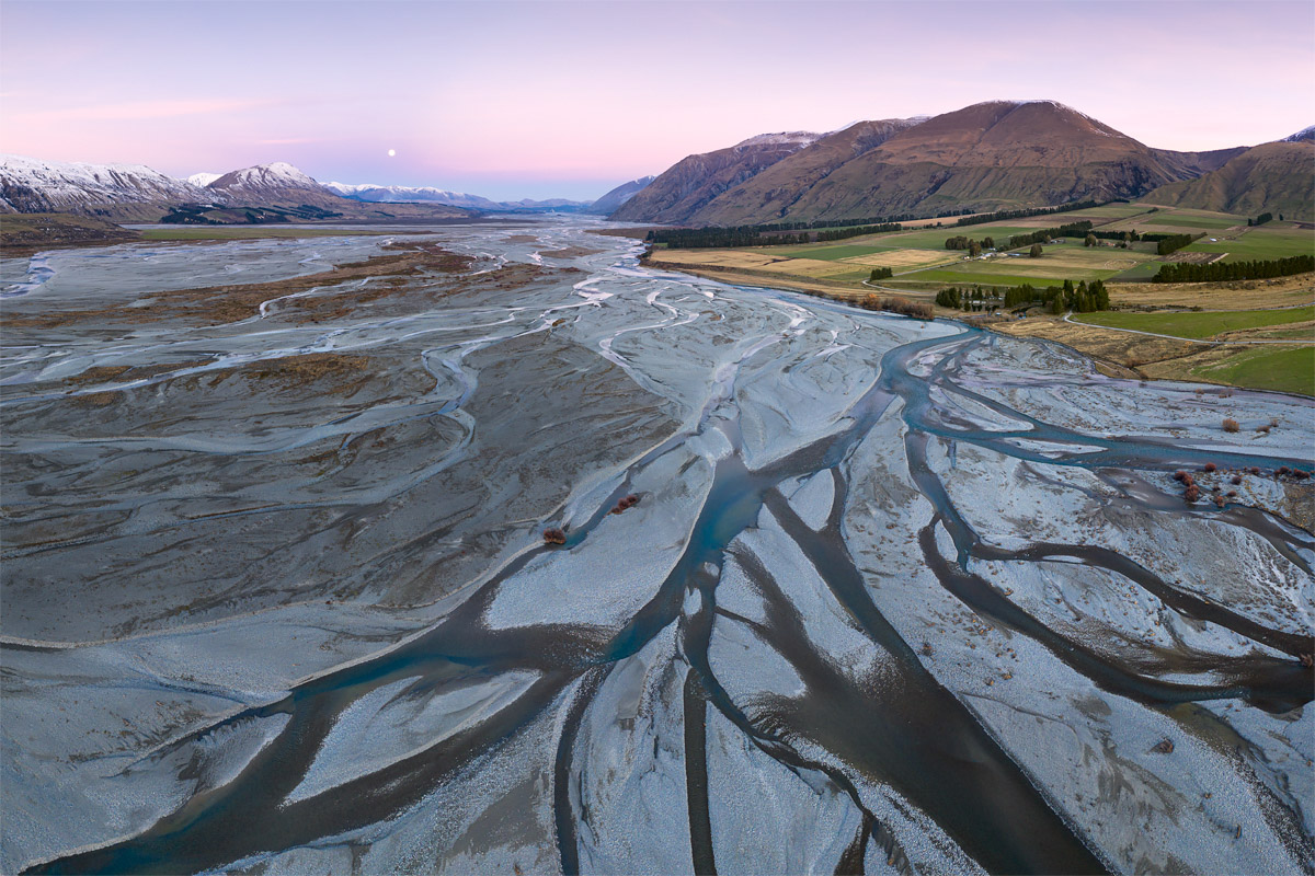
The many braids of the Rakaia River (click image to purchase print)
Day 1
The off-roading is a serious undertaking. An immediate crossing of the main branch of the Rakaia is required (involving several bonnet-high braids even on a fine day) followed by several smaller streams and another major crossing of the Rakaia at Totara Point. Being flung round the cab through the rough and bouldery terrain gave me a full body workout, providing a good warmup for the day ahead!
We made our way slowly up valley, coming close to several huts along the way. Ownership of these facilities varies, including some privately owned by Lake Heron Station. In total it was a 25 km and two-hour trip up valley to my drop-off point, Reischek Hut, which thankfully saved me around 5 hours of valley trudging (I’d later walk much of this section in a snowstorm on Day 5). As my ride returned down valley and disappeared behind a distant bluff, it was with a mix of both excitement and trepidation that I realised I was now all on my own for the next five days.

The 6-bunk Reischek Hut, run by the Department of Conservation

The rustic interior of Reischek Hut
My destination was Lyell Hut, located around 3 hours walk up valley. Setting off under blue skies and a light breeze at 2.30pm, the forecast for the remainder of the trip looked reasonably good; perhaps a brief skiff of snow the following day, followed by a clear period and then a storm moving in towards my last day. Timing a good weather window in this part of the world can be endlessly challenging; here the annual rainfall is measured in metres, winds can knock you off your feet, and snow can fall at anytime of the year. Any number of weather or river related issues could’ve prevented this trip from even starting. I felt very lucky to be out here.
Lifting my pack onto my back for the first time I realised just how much gear I was carrying. In addition to my usual gear (full breakdown in this blog) I was also carrying my drone (and its three batteries), bringing up my total pack weight towards 28 kg.
Beyond Reischek Hut the route is untracked. The terrain remains at a flattish gradient but is uneven underfoot; great ankle rolling territory if you’re not concentrating. Around 30 minutes in the Rakaia comes in close and deep to the southern bank necessitating a brief scramble above bluffs and through scrub. Soon after Reischek Stream is forded before reaching the river terrace beneath Meins Knob. At this point I first encountered snow on the ground, which hadn’t yet melted after a storm a couple of weeks prior.
A marker post (click for topomap location) indicated I was at the point where two paths forward presented themselves: a 400m climb and then descent over Meins Knob (via the Glenfalloch Route), or carry on up river and take the lower route just above the true-right of the river. I climbed a little way up the hill and soon encountered firm ice and indications it was going to get more arduous. The lower route it is for me.
Following a scramble along the bouldery river bank I then pushed my way through a section of tall grasses and countless hidden holes. Eventually the swingbridge accessing the true-left came into sight, but not before a ladder climb up a bluff. I didn’t intend to cross, as that would put me on the wrong side of the river to Lyell Hut. Rather, I was planning to connect with the trail supposedly just up the hill. But after several steep and fruitless forays through bluffy territory I retreated back down to plot my next move.

Views from part way up the rock slide towards the Ramsay valley (left) and from the first section of the Glenfalloch Route looking back down the Rakaia valley (right); both screen grabs from video as I didn’t take any photos at these locations
Surely the trail must be there somewhere? Several large rocks slides off Meins Knob looked to provide useful ascent points so I walked a few hundred metres back downstream to begin another climb. Back in the tall grasses I was surprised to find a shoe lying among the flaxes. Wait a second – that’s MY shoe! I’d earlier tied my spare shoes to the outside of my pack and one must’ve fallen off; what great luck to have found it! However, to my dismay I then discovered my other spare shoe had also gone walkabout and was nowhere to be seen. Light was beginning to fade so after a quick and unsuccessful looksee I made the call to move on. No dry footwear option for the rest of the trip.
After an 80 metre climb up one of the rockslides my GPS showed I should’ve been standing directly on the trail, but there was no sign of it. A further 50m vertical; still no trail. And impenetrable bush in the direction I should be going.
Now reasonably exhausted and the sun well and truly set, I sat at the top of the rockslide and realised it was very unlikely I could make it to Lyell Hut. Not without climbing through ice and snow, and not without crossing the swingbridge and then later fording an icy cold river; both options in the dark. I felt so close to my destination yet so far away.
With a large degree of frustration, but what I knew to be the right thing to do, I retraced my steps back to Reischek Hut in the dark. I arrived back around 8pm, cooked up a feed, then collapsed into my sleeping bag. The next day I would start again.
Day 2
The day dawned under a nor-west sky. As per the forecast, thick overhead cloud and a stronger breeze signalled a stint of inclement weather was close. I made an early start.
Back at the marker post I went for another wander up the Glenfalloch Route to confirm whether or not it’d be worthwhile, with full daylight hours now available, to give this option a go. The snow still resembled bullet-proof ice and as I wasn’t carrying crampons and an ice axe I decided against it. My remaining option was therefore to cross the swingbridge and head an hour or so up the true-left of the valley. This meant I would eventually need to ford the unknown depths of the river, which left some uncertainty in the day ahead. But it was my last option so I’d at least go and take a look, and if it didn’t work out, I could make it back to Reischeck Hut and call a reluctant end to this adventure.
Once back up the ladder and over the swingbridge I slipped and slided through the icy and rocky moraine of the retreated Ramsay Glacier. It’s incredible to think that when Julius von Haast first explored this area 157 years ago, in search of a new road to the West Coast, the Ramsay Glacier (as well as the Lyell) terminated at the foot of Meins Knob. von Haast recorded:
“[The glacial torrent] was confined, on the other side, by the rocky walls of Mein Knob, forming a narrow gorge. I tried in vain to pass along, but, partly owing to the slippery nature of the ice against which the turbulent waters were flowing, partly to the huge blocks of rock falling from the top of the glacier, and the almost continuous shower of smaller debris, I had to give up the attempt to reach the upper part of the valley by skirting this, which I have named the Ramsay Glacier.”
Now both glaciers have retreated 3 km up the valley and have large lakes at their terminus.


The Ramsay and Lyell Glaciers viewed from Meins Knob, as documented by Julius von Haast in June 1866 (source: Auckland University)
Eventually the moraine gave way to easier terrain and firm snow made travel reasonably fast. It wasn’t too long before Lyell Hut came into view. Here the river was full of large boulders and the milky water, full of glacial silt, made it difficult to see the bottom. After investigating some options I found a wide point where the water was calmest and, I surmised, likely to be the shallowest. To my pleasant surprise the deepest point was only just over knee deep, although the icy coldness was everything I expected!
Just as I arrived at Lyell Hut the first few snow flakes began gently falling. Thankfully the building, recently replacing the original hut constructed in 1931, is fully insulated and relatively easy to keep warm with the logburner. The Canterbury Mountaineering Club has done a stellar job. Nightly fees are $15 (for non-members) and can be made online (note: DOC tickets are not valid at CMC huts).
With snow continuing to fall I snuggled into my sleeping bag for the remainder of the day and read my Kindle. Photographs could wait until tomorrow.

Lyell Hut interior with Mt Whitcombe perfectly framed in the northern window

Lyell Hut sleeps approximately 8 on the platform bunks
Day 3
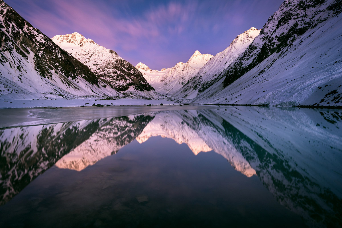
After an early alarm I dressed up warm and began the walk to Lyell Lake, the ultimate reason for this trip. The lake sits at the outlet of the Lyell Glacier, and along with the Ramsay, are the northern-most valley glaciers in New Zealand. If I came away with only one image from this adventure it was to be of this lake and its spectacular surrounds.
A million stars twinkling in the sky were mirrored by the snow sparkling under the light of my headlamp. As I crunched my way across the firm snow the impressive peaks at the head of the Rakaia began glowing with first light, leading me to pick up my pace. After 30 minutes or so the lake edge emerged from the relative darkness and I couldn’t quite believe what I was seeing; the scene was everything I had dreamed of and more.

My first sighting of Lyell Lake

Lyell Glacier and terminal lake; Mt Nicholson (2,367m) and Malcolm Peak (2,512m) are the two prominent peaks at the rear

An aerial perspective of Lyell Lake

The Lyell valley viewed from the lake outlet downstream towards Lyell Hut
Lyell Lake was fully frozen save a small area at its outlet which reflected the entire mountainous surrounds. I must’ve spent a couple of hours around here both taking photos and at times just standing still and taking it all in. Once the sun arrived in the valley floor I set off to explore the head of the lake but eventually turned back due to the large amount of rockfall dislodging from the mountainsides in the sun’s heat.
I returned to Lyell Hut for a late lunch with the thought of climbing Meins Knob that afternoon. After taking a while to find the route (it’s around 5-10 minutes walk downstream of the hut) the steep icy snow again put me off going any further. Furthermore it became apparent the tarns I’d intended to photograph would be well and truly frozen and completely buried beneath snow. They’d need to wait to a future trip.
I decided to head back up to Lyell Lake for sunset opportunities, but it ultimately proved uneventful. Following the return walk in the dark I tuned into the nightly mountain forecast on the hut radio, which confirmed the snowstorm towards the end of my trip was on track. The thought of trudging through 35 km of snow on my last day, coupled with the risk of snowmelt and raised river levels, was cause enough for me to change my plans. So rather than staying at Lyell Hut I’d leave tomorrow and head down valley as far as I could.

The end of a wonderful day in the Lyell Glacier valley
Day 4
One last sunrise. As I again made the journey up valley in the dark there weren’t quite as many stars in the sky as yesterday. Instead I could make out some wispy high cloud, which boded well for photography. And so it turned out to be; if I thought the previous morning was epic then nothing prepared me for this.
First light at Lyell Lake (click image to purchase print)

The beautiful light and colours kept on giving

The view in the other direction (click image to purchase print)

The lake was frozen solid and safe to walk on, although I didn’t risk walking too far out!
Returning to the hut I packed up and with some sadness made my departure. Immediately my boots got wet crossing to the true-left and they were to stay this way for the rest of the trip. Eventually I again reached the rocky moraine of the Ramsay Glacier but this time headed north and picked my way towards a frozen Ramsay Lake. After dropping the pack and briefly exploring the surrounds I forded the lake outlet (which was reasonably shallow) and had lunch on the other side.

Ramsay Lake and Mt Whitcombe (2,650m); this old weather station and lake level recorder has seen better days!
Heading downstream I passed under the ramparts of Jims Knob and within 1 km or so the snow petered out and I crossed a mix of boulders, gravel and subalpine gardens. Soon after fording Lauper Stream I reached the 2-person Lauper Biv, which is often used by those heading up to Whitcombe Pass and over to the West Coast. Around another 1km downstream, the Rakaia comes in close to the valley side and some boulder scrambling under an eroded bank is required. A further mix of gravel bashing and grassy meadows then follows.
I arrived at Evans Hut under grey skies just before sunset. The conditions looked ripe for snow but no flakes were falling as yet. The forecast had said snow down to approximately 800m, and with Evans Hut sitting around the 740m contour, there was every chance I’d miss it. Overnight I slept reasonably soundly but in the brief moments I awoke I listened out for precipitation but heard nothing.
Day 5
Morning dawned and to my surprise I discovered it had indeed been snowing; a blanket of several centimetres coated the ground and surrounding beech forest. The remaining 18km was to be a cold one. While I wasn’t apprehensive about walking in a blizzard (many years experience both tramping and skiing provide good tests for the limits), I was increasingly concerned about the potential for melting and the Rakaia River to rise, meaning my only way out and home would be cut off.

Evans Hut: the afternoon before / the morning after
The 18km proved to be a long trudge. One foot in front of the other, counting off the kilometres one by one. Over five hours I only paused once for a brief drink, being keen to get to that last river crossing of the Rakaia as soon as possible. Arriving at the first braid I was thankful to find the river hadn’t risen too much; there were multiple and swift channels to cross but none more than thigh deep. My walking pole came in handy for stability.
With some relief I finally reached my car at 1pm. Just a few hours later the river became completely impassable.
An epic adventure complete
After all the years of dreaming and planning for this adventure it was the best of feelings to finally make it happen. Travelling solo in the depths of a cold winter had been both a mental and physical challenge, but one which I thoroughly enjoyed. I can now understand why during my research I’d found so few photographs of this place and why it’s so seldom visited. For those willing to test their limits, some epicness awaits.
Trip undertaken 4-8 July 2022. Here’s a highlights reel of those epic moments. If you have any questions, please ask away in the comments!
Leave A Comment