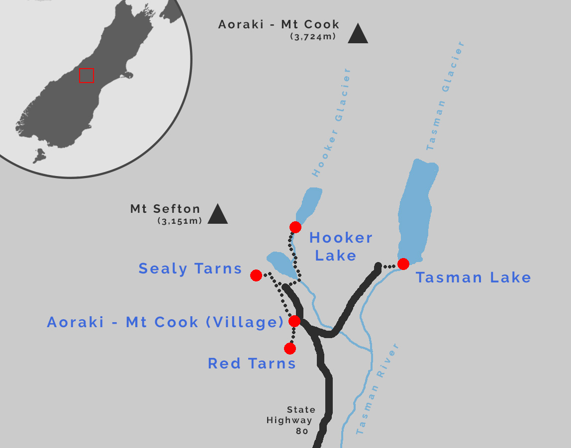
A Brief Guide to Aoraki/Mt Cook National Park
New Zealand has 20 peaks which climb over 3,000m above sea level. Ever the greedy national park when it comes to scenery, Aoraki/Mount Cook National Park is home to 19 of them, with the centrepiece being our tallest mountain, Aoraki/Mt Cook itself (3,724m). Over 40% of the park is glaciated, with Tasman Glacier (25km) and Hooker Glacier (11km) being two prominent features on the flanks of Aoraki/Mt Cook. The park is recognised for its outstanding natural values and forms part of the internationally celebrated Te Wāhipounamu – South West New Zealand World Heritage Area.
Photography opportunities abound, with many amazing viewpoints able to be reached on foot.
Aoraki / Mt Cook Village
The village is located entirely within the national park. Because of this development is tightly controlled and facilities are relatively minimal.
There are a small number of accommodation providers, the most well known of which is The Hermitage. The Department of Conservation campground at White Horse Hill provides spots for tents and parking the motorhome for the night. Glentanner, located 24 km back down the road, has a holiday park style facility.
Dining options are very limited and there is no supermarket (Twizel is the nearest option at 64 km distance). Self-service petrol is available.
Getting there: State Highway 80
The drive into Aoraki – Mt Cook via State Highway 80 passes up the western flank of the 31 km long Lake Pukaki. On a clear day the sight of Aoraki-Mt Cook climbing out of the glacial turquoise waters is something so amazing that it almost defies reality. Peter’s Lookout, located around 12 km after the turnoff from State Highway 8, offers the most iconic spot to view the surrounds.
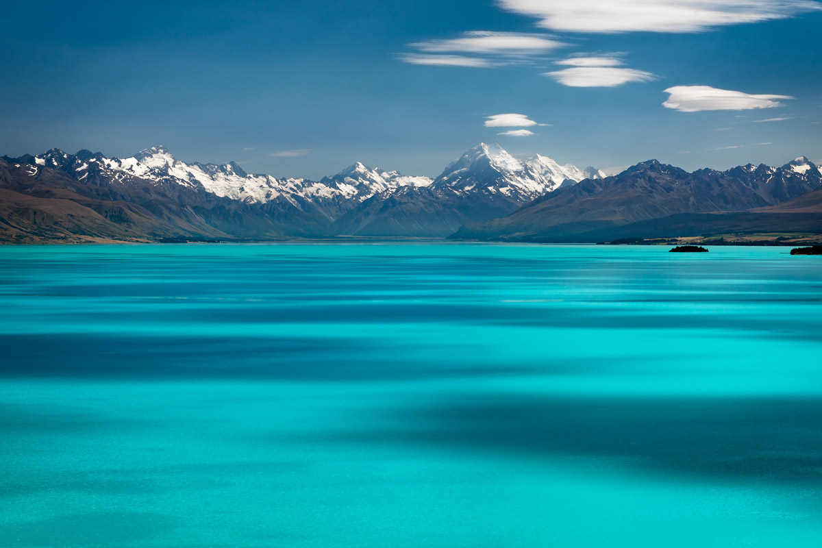
Aoraki-Mt Cook viewed across the glacially sourced water of Lake Pukaki; SH80 heads up lake on the left hand side of the image

The iconic view from Peter’s Lookout across Lake Pukaki to Aoraki / Mt Cook

Lenticular clouds are a reasonably common feature around these parts, caused by the predominant westerly airflow over the Southern Alps

Getting closer now… Aoraki looms large.
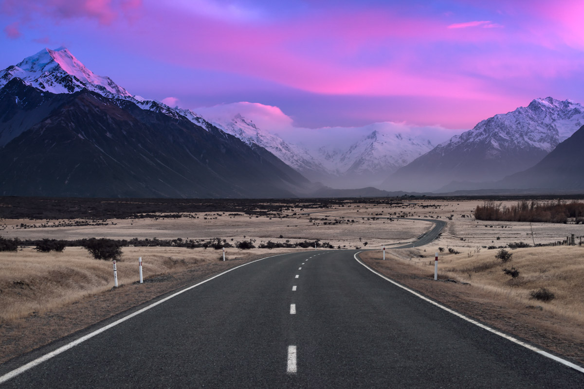
Approaching the national park boundary at sunrise, with a view towards the Tasman Valley.
Hooker Valley Track
This is the most popular walk in the area, and it’s fairly easy to see why: it takes you through spectacular glaciated mountains, meltwater lakes, raging rivers, and alpine meadows, to what feels like the toe of Aoraki – Mt Cook itself. Starting from the White Horse Hill campground and carpark, the track takes around 1.5 hrs (one-way) to reach Hooker Lake, gaining around 80m over 5 km. The track is well graded and board-walked in places, and there are three swingbridges to cross.

The is the view from Mueller Lookout, which is reached around 10-15 mins into the Hooker Valley Track

Mueller Lake and Mt Sefton as seen from the first swingbridge (the bridge can be seen in the bottom-right corner of the previous image)

At about the halfway point to Hooker Lake, the track drops down beside the Hooker River and provides dramatic views towards Aoraki / Mt Cook

I’ve been into Hooker Lake several times and always found it a very challenging place for photography; I’ve yet to come away with an image I’m truly happy with!
Tasman Lake
There are several tracks starting from the Tasman Lake carpark. For a quick view of the lake, head up past the Blue Lakes to a viewpoint on the moraine wall (approx. 15 mins one-way). There are good views of the lower Tasman Glacier, lake, and the mountains at the head of the valley. I like this spot for its views, but it’s not my go to place for photography.
For that I head to the Tasman Lake outlet (approx. 25 mins one-way). This location provides plenty of awesome foreground interest for photography, be it icebergs floating on the lake after a glacial carving event, a frozen surface in winter, or the water current where the lake drains to the Tasman River.

Looking back down the Tasman Valley from the Tasman Lake lookout track

During winter the lake often freezes and creates an iceberg graveyard

That graveyard looks even better on a moonlit night!
Sealy Tarns
Spectacular views often require a spectacular effort to reach. Such is the case with the 2,200 steps required to gain the 600m elevation to the Sealy Tarns. Starting from the White Horse Hill carpark and taking around 3-4 hours (return), the tarns offer extensive views down the Hooker Valley towards Aoraki/Mt Cook and across to avalanches tumbling off Mt Sefton.

Taken around 1500 steps up the Sealy Tarns Track, viewed across Mueller Lake to the Hooker Valley

The biggest of the Sealy Tarns, iced over in early winter (June)
Red Tarns
If tarns are your thing, but the mere thought of climbing 2,200 steps to the Sealy Tarns puts you in a sweat, then the Red Tarns is your next best option. With a 300m elevation gain up what is mostly stairs the track is still a reasonable slog, but can be completed in around 2 hours return. The westward facing views across Aoraki/Mt Cook village towards Mt Sefton and Aoraki / Mt Cook make this a perfect spot to watch the sun go down.

Late afternoon light on a still winter’s day at the Red Tarns

Aoraki / Mt Cook Village viewed from the lookout at the Red Tarns
Leave A Comment